A tube train arrives at Totteridge & Whetstone.

Thursday, 30 November 2023
Tuesday, 28 November 2023
Street name signs of Birmingham (5)
And finally in our survey of the metal street name signs of Birmingham, we look at a few oddities. The standard form for signs is for the street name to be in black (on a white background) and the postcode in red. Any extra information underneath the street name is in black. This is usually adhered to but there are a few examples around the city where it isn't quite right!
 |
| Back Road, Kings Norton |
 |
| Greenfield Road, Harborne |
 |
| Mill St, Aston |
Finally, we have a Birmingham pre-war street name sign... but in Southam, Warwickshire! There must be an interesting story about this sign...

Monday, 27 November 2023
A walk along the Sheffield & Tinsley Canal
It has been awhile since i walked along a new canal for the first time, the last one was probably the Shropshire Union Canal last year. On Saturday i walked the Sheffield & Tinsley Canal from it's city centre terminus out as far as (near) Hyde Park tram stop. You can see my photos here.


Sunday, 26 November 2023
Sheffield steel
It has been a number of years since my previous visit to Sheffield, too long in fact. Yesterday, i rectified that at last and enjoyed plenty of journies on the city's superb tram network going as far as Rotherham on the tram train. This time i also visitied the cathedral which i had somehow forgot to properly visit about on my previous visit! I also had a walk along the Sheffield & Tinsley Canal but that will be covered another time. You can see my Supertram related photos here and some other Sheffield photos, including the cathedral, here.


Friday, 24 November 2023
Street name signs of Birmingham (4)
There is one more type of street name sign in Birmingham which needs to be mentioned. These are the signs for the Queenway roads (or Ringway roads) that survive from the post-war ring roads around the city centre. These have a style similar to the other post-war signs discussed in part 3 of this series but have red letters on a white background and a red border.
 |
| Great Charles Street, Queenway |
Also in part 3 we mentioned that the new sign design was larger and therefore could include extra information about the road, such as if the road was a cul-de-sac. Before that, with the pre-war signs, that information was denoted using a small additional sign placed underneath the main sign. There was also one which said "leading to" though this seems pretty rare, i have only seen this in one place.
 |
| Key Hill, a Cul-de-Sac |
 |
| Northampton Street which leads on |
Finally, pre-war signs in the 1930s the street name signs began to carry the postal distict number. In the Jewellery Quarter can be seen a "number 1" sign which carries the same information. I wonder if any more of these have survived?
 |
| Postal District 1 |
Thursday, 23 November 2023
Wednesbury Old Canal
The Wednesbury Old Canal is part of the Birmingham Canal Navigations. Despite being a fairly short canal (just over seven kilometres) it performs an important job in that it links the Walsall and Birmingham Main Line Canals. The canal was opened as part of the original Birmingham Canal in 1769. Later canal building (or rather re-building) replaced part of its stretch especially where it needed to meet the Birmingham New Main Line.

Like the majority of the canal network, the Wednesbury Old Canal went into decline in the 20th century and was considered abandoned in the 1950s. However, parts of the canal are still available for navigation and others are on the whole still watered.
The Ridgacre Branch and the canal from Swan Bridge Junction to the original termination point at Balls Hill Basin are no longer accessible to boats due to a new road bridge which left insufficient headroom for boats.
The canal is still navigable for over a mile between Pudding Green and Ryder's Green Junctions (and a little beyond the latter).


Monday, 20 November 2023
Street name signs of Birmingham (3)
After the Second World War many places in central Birmingham needed reconstruction after the Blitz, and many people moved out of the old central areas to new build suburbs as the city expanded into places like Shard End. A new design of street name sign was also developed, a more modern design befitting the times. The new signs used a sans serif font on a utilitarian rounded rectangle design. The new design gave sufficient space for additional information such as if the road was a cul-de-sac. The signs usually included the postcode.
This design is still very common across the city especially on post-war estates. It remained the standard until Birmingham switched to printed vinyl signs in the late twentieth century. The early form of these copied the same typeface and design.
 |
| Firtree Road, Erdington |
 |
| The Shardway, Shard End (notice the cul-de-sac information) |
 |
| Poplar Road, Edgbaston |
 |
| Printing House Street, Birmingham |
Sunday, 19 November 2023
Saturday, 18 November 2023
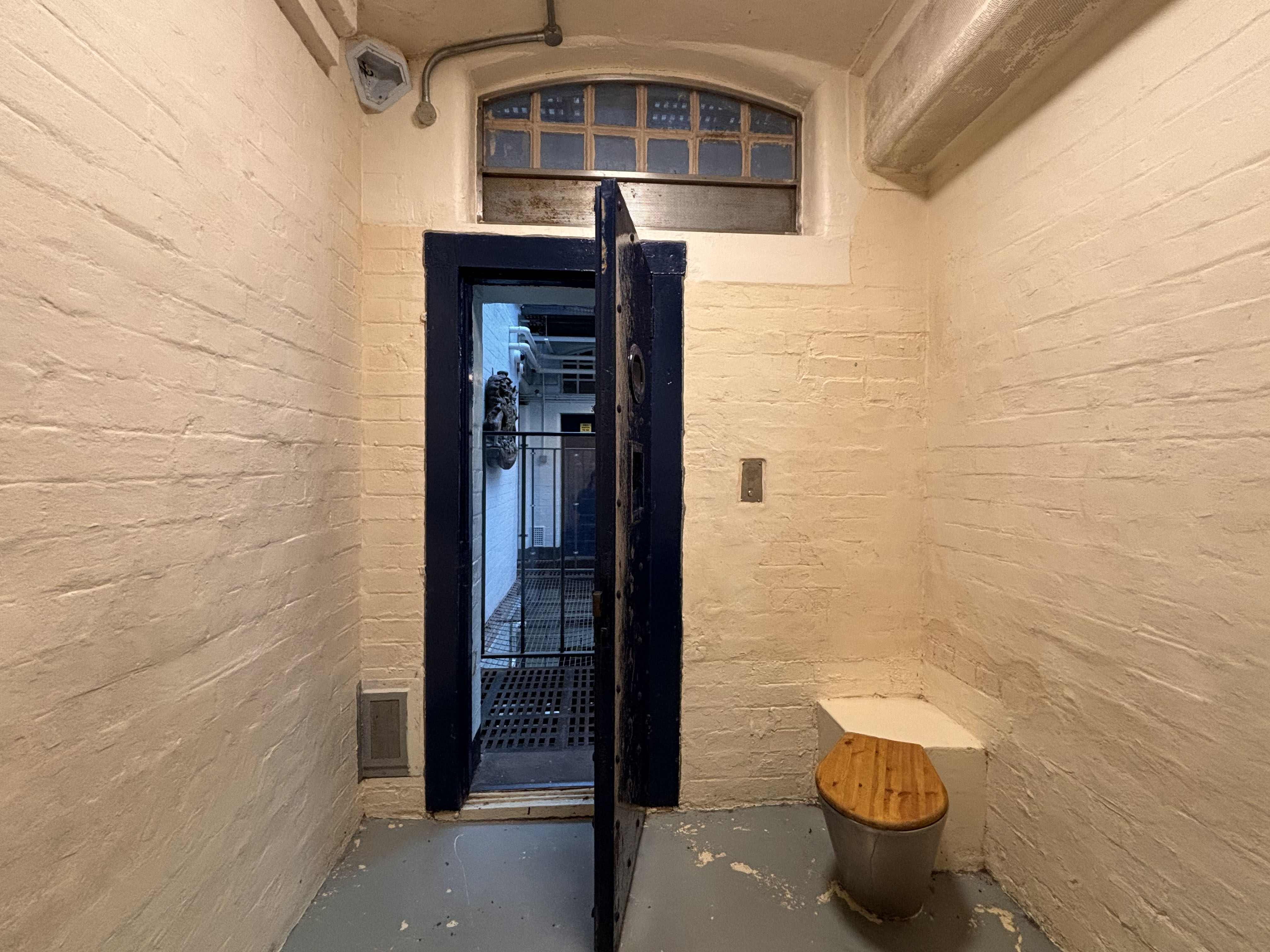
West Midlands Police Museum
No trains this weekend, instead i headed to the West Midlands Police Museum which is located in a former police lock-up next to the law courts (in fact the building was in police use until 2016). I explored the cells (luckily none were locked behind me!) The museum has a number of interesting exhibits and is well worth a visit. You can see my photos here.


Friday, 17 November 2023
Street name signs of Birmingham (2)
In the early 20th century the fast growing city of Birmingham developed a new standard design for it's street name plates. The design was similar to the octagonal signs of before though was more elaborate with fleur-de-lis at each end. The typeface used was Baskerville Print which had been designed by Birmingham printer John Baskerville.
The signs were used throughout the city and can be seen in many places with pre-Second World War housing. The oldest signs just had the street or road name on them though some later signs also included the postcode after Birmingham introduced them in the 1930s.
An interesting variation on the signs is with abbreviations. Words like "road" and "street" are shortened on some signs though written in full on others even though there is little actual difference in the length of the sign! Even how the abbreviation was made could vary. Signs were either wall mounted or in many cases mounted on an elaborate metal stand as shown below.
 |
| Tyburn Road, Erdington |
 |
| Orphanage Road, Erdington showing the postcode |
 |
| Hinckley Street in the city centre |
 |
| Chantry Road, Moseley |
Thursday, 16 November 2023
The Cromford Canal
The Cromford Canal was built in Derbyshire to connect Cromford with the Erewash Canal at Langley Mill. It originally stretched for over twenty three kilometres though much of the canal is now either lost or unnavigable.
Work began in 1789 after receiving an Act of Parliament. However, the building of the canal did not run smoothly. The contractors walked out in 1790 due to issues with costs. The original engineer William Jessop had underestimated how much the canal would cost to complete.

William Outram took over the project and took it to completion, but the canal proved a complicated and difficult affair involving the building of a number of tunnels and aqueducts. The first parts of the canal (on the Pinxton Arm) opened in 1792 but delays and difficulties with construction elsewhere such as at the Butterley Tunnel meant that the canal didn't reach Cromford until 1794 [1]. The Nightingale (also known as the Leawood) Arm, which was built by Florence's great-uncle, opened in 1802 [2]. The Cromford & High Peak Railway, which opened in 1831, connected to the canal at High Peak Junction giving the canal a boost allowing trade up to Manchester.
In the end, the canal cost twice as much as originally envisaged but it was a financial success. The canal carried limestone, coal, lead and iron ore amongst other cargos. By the 1840s the canal was carrying over 300,000 tons of cargo a year but, as with all of the canals at the time, the coming of the railways eventually eclipsed it and by the late 1880s cargo has dropped to less than 50,000 tons. The canal was bought by the Midland and London North Western Railways and was used for local traffic.
The canal was largely abandoned in the early 20th century with some parts of it being lost due to subsidence such as at Butterley and by road building [3]. The canal was officially abandoned in 1944.
Only a short stub at Langley Mill where it joined the Erewash and Nottingham Canals remained in use. However, restoration efforts began in the 1970s with the towpath restored from Cromford to Ambergate and some navigation possible, though at the moment only the stretch from Cromford to the Leawood Pump House (around two km) is fully watered and navigable. The canal retains some water as far as Ambergate.


[1] Hugh Potter, The Cromford Canal (Tempus, 2003) p. 11
[2] Ibid. p. 106
[3] Ibid. p. 67
Wednesday, 15 November 2023
Monday, 13 November 2023
Street name signs of Birmingham (1)
Knowing where you are in a place is always very important. Unlike a lot of locations around the country where standardisation is the word, there is quite a variety of designs of street name signs in Birmingham which this series will look at. We will only cover metal signs, not the plastic ones which took over in the 1990s.
The oldest signs date back to the Victorian years and survivors these days are fairly rare. They had a simple octagonal design with black letters on a white background. They can still be seen occasionally in some of the oldest (and less changed) parts of the city.
 |
| Cotton Lane, Moseley |
 |
| Well Lane, Digbeth |
 |
| Tenby Street North, Jewellery Quarter |
Sunday, 12 November 2023
Back to Birkenhead
I went to Liverpool a few weeks ago and was shocked at how fast the new Merseyrail trains were taking over from the old BR era Classes 507 and 508 trains. Thus i headed back up yesterday to check out the old trains before it is too late! The old trains are mainly on the Wirral now so i took the opportunity to visit Bidston and also a church in Birkenhead. You can see my photos here.


Friday, 10 November 2023
Churches (205) : St Luke, Lowsonford
The parish church of St Luke in Lowsonford, Warwickshire was opened in 1877 as a chapel of ease to the church of St Lawrence in Rowington. The church has a simple plan, consisting of a nave only and is pretty much unchanged since it's building. The altar is separated from the rest of the church using a rail. The church is made chiefly from brick, with buttresses and a belfry.


Thursday, 9 November 2023
Monday, 6 November 2023
Priories (10) : Kenilworth
An Augustinian priory was created in Kenilworth in 1124 by Geoffrey de Clinton who also built the nearby Kenilworth castle. The parish church of St Nicholas was built next to the priory in about 1291. The priory was promoted to an abbey by the Pope in 1447, by then it had been considerably built up and included an infirmary, gatehouse and a barn.
The abbey was dismantled following dissolution, only the barn and parts of the gatehouse remain today though the remains of the other buildings have been excavated.


Subscribe to:
Posts (Atom)